LOAD SHEDDINGChecking the official ministry feed…
Check ministry ↗ECUADOR · ELECTRICITY BRIEF
Power today
Loading latest results…
First edition — this page is an evolving public prototype and will likely change as we learn what is most useful.
INFORMATION CHECKED
21 OCT 2026 · 10:30 ECT
Some measurements below have older source times.
NATIONAL GRIDChecking production and demand…
CENACE ↗LOCAL CONTEXTChecking CNEL planned work…
Check CNEL ↗THE THREE SIGNALS
What changes the outlook
Water in reserve, water arriving, and the rest of the generation system must move together before the risk materially changes.
MAZAR RESERVOIROFFICIAL CELEC
2,1532,098
2,121.30m a.s.l.
↓ 0.21 m / 24 h
Inflow 50.53 m³/s
Checking official CELEC observation time…
Open CELEC reservoir data ↗PAUTE BASINRAIN & INFLOW
Checking Mazar inflow
The live updater compares official inflow with the same hour yesterday. This is a water-response signal, not a rain measurement.
WHERE POWER CAME FROMOFFICIAL CENACE
ENERGY · SO FAR TODAY
40,165MWh supplied
≈40,136MWh used in Ecuador
63.7%Hydro35.4%Thermal0.4%Renewable0.4%Imported
Imports 169 MWh · exports 29 MWh
POWER · AT 11:00
3,967MW required
2,697Hydro MW1,165Thermal MW56Renewable MW50Imported MW
Checking the latest preliminary CENACE SCADA snapshot…
The page also checks automatically when opened.
RAIN IN THE RIGHT PLACE
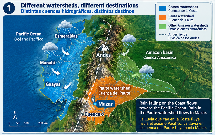
Coastal rain does not refill Mazar
Mazar depends on the Paute watershed east of the Andes. Rain in Manabí can be important locally without improving Ecuador's principal hydroelectric reserve.
OPEN THE LIVE DATA
Five useful live sources
DETAIL, ON DEMAND
For the curious
A thank-you to the CENACE Monitor project+
The independent CENACE Monitor preserves official CENACE snapshots every 30 minutes and turns a momentary government display into understandable history, comparisons and downloadable data. That careful open-source work makes this page's on-demand grid update possible. We are grateful to its creator, Pablo Jiménez. CENACE remains the authoritative underlying source.
Visit the CENACE Monitor ↗A thank-you to Hidro Info Bot+
Hidro Info Bot has made Ecuador's hydroelectric situation easier for the public to follow by collecting and explaining information that is otherwise scattered and difficult to read. We appreciate the time and public-service spirit behind that work. It is an independent monitor, not an official CELEC or CENACE source.
Follow on Instagram ↗Water measurements and caveats+
The displayed Mazar elevation, inflow and 24-hour change use CELEC SUR's official hydrology measurements. The site checks hourly in the background and, if needed, when the page is opened. It keeps the last valid observation if CELEC has not published a newer usable reading. Elevation is not the same as percent full; conversion requires the reservoir's storage curve. The operational elevation range shown is 2,098–2,153 metres.
Official CELEC hydrology dashboard ↗Forecast versus observation+
Windy's rain layer is a model forecast. Satellite imagery observes clouds. INAMHI stations observe conditions at specific points. Ecuador does not have a public nationwide real-time weather-radar composite, so the page does not label any of these as national live radar.
What counts as a major outage+
This brief tracks official load-shedding schedules, national-grid emergencies, citywide or multi-community outages, and major transmission or substation failures. It does not attempt to log individual homes, routine feeder faults or brief neighborhood interruptions.