Biblioteca de referencia sobre Ecuador

Explicadores

Guías de contexto sobre la política, economía, historia, ambiente y vida cotidiana del Ecuador.

← Todos los recursos

La mayoría de los artículos están actualmente disponibles en inglés.

Limpiar

Manabí

Explora los explicadores

7 artículos

Why was Portoviejo Founded?

Portoviejo holds a prestigious spot in history as one of the oldest Spanish-founded cities in present-day Ecuador. Founded on March 12, 1535, it wasn't just a random settlement—it was a calculated move by the Spanish Empire to secure the coast. Why was Portoviejo Founded? The founding of San Gregorio de Portoviejo by Captain Francisco Pacheco was driven by three main goals: Strategic Control: The Spanish needed a ba…

Leer el explicador →
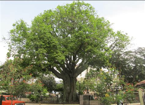
Explainer | The Ceibo (Ceiba trichistandra) — the Coast’s “big-hearted giant”

First: what people mean by “ceibo” on the Ecuadorian Coast On the Coast, when someone says “that’s a ceibo”, they’re usually talking about Ceiba trichistandra — the classic giant of Ecuador’s tropical dry forest (bosque seco) in the Tumbes region (Ecuador–Peru). (iNaturalist) (Tiny note because it confuses everyone at some point: there are other “ceibas” too — like Ceiba pentandra in wetter tropical areas — but the…

Leer el explicador →

Explainer- The Portoviejo–Manta–Bahía Corridor: One Coastal Region, Three Different Economies

The Portoviejo–Manta–Bahía Corridor: One Coastal Region, Three Different Economies (with Crucita, San Clemente, San Jacinto, Canoa, Chone, Calceta, Tosagua, Rocafuerte, Bahía de Caráquez & San Vicente in the background) 1. One corridor, many economies If you look at a map, Portoviejo, Manta and Bahía de Caráquez/San Vicente sit along one logical coastal corridor: farms and small towns in the interior, a capital city…

Leer el explicador →

Explainer - Portoviejo's Urban Lab

Here’s your explainer, with a short bilingual wrap-up at the end.(And as requested on earlier pieces: this article was created by ChatGPT.) Portoviejo’s Urban Lab: how Ecuadorian cities are trying to change for their citizens 1. What is an “Urban Lab”? An urban lab is basically a city-sized workshop: a place where local government, universities, citizens and sometimes NGOs test ideas using real data from the city. I…

Leer el explicador →

Explainer Manta’s hydrosanitary master plan:

Explainer / Explicador Manta’s hydrosanitary master plan: how it works, who pays for it, and what it means for the cityEl Plan Maestro Hidrosanitario de Manta: cómo funciona, quién lo financia y qué significa para la ciudad 1. What is Manta’s hydraulic / hydrosanitary plan? 1. ¿Qué es el plan hidráulico / hidrosanitario de Manta? EN:When people in Manta talk about the “Plan Maestro Hidrosanitario” or “Plan Maestro d…

Leer el explicador →

Explainer plus-Use of large rocks (riprap) to control coastal erosion

Uso de piedras grandes (riprap) para controlar la erosión costera Use of large rocks (riprap) to control coastal erosion 1. ¿Qué es el riprap? / What is riprap? ES:El riprap (o escollera) es una capa inclinada de piedras grandes y angulares colocadas en la orilla, frente a un malecón, carretera o edificio. La idea es que las rocas rompan la energía de las olas antes de que golpeen directamente la tierra o el hormigó…

Leer el explicador →

Explainer- Coastal erosion and sea-level rise on Ecuador’s coast

(with examples from San Jacinto & San Clemente) 1. What is coastal erosion? English Coastal erosion is the gradual loss of beach and land caused by waves, tides, currents and storms. Little by little, the shoreline moves inland: the beach gets narrower, dunes disappear, and sometimes roads, houses or seawalls collapse. On Ecuador’s Pacific coast, erosion is not new. Studies show that the central Manabí coastline has…

Leer el explicador →