Living in Ecuador · Geography & Environment · Infrastructure & Energy · Water · Watersheds · Hydroelectricity · Mazar · Paute · Flooding
Floods but Not Enough Water for Electricity? How Ecuador’s Watersheds Explain It
Why flooding on Ecuador’s Coast can happen while Mazar receives too little water—and why hydroelectric generation depends on sustained rain in the right watershed.
Published Updated

Heavy rain has flooded parts of Ecuador. Rivers have overflowed. At the same time, Mazar—one of the country’s most important hydroelectric reservoirs—has been losing water.
How can both things be true?
The answer is geography. Ecuador does not have one shared bucket of water.
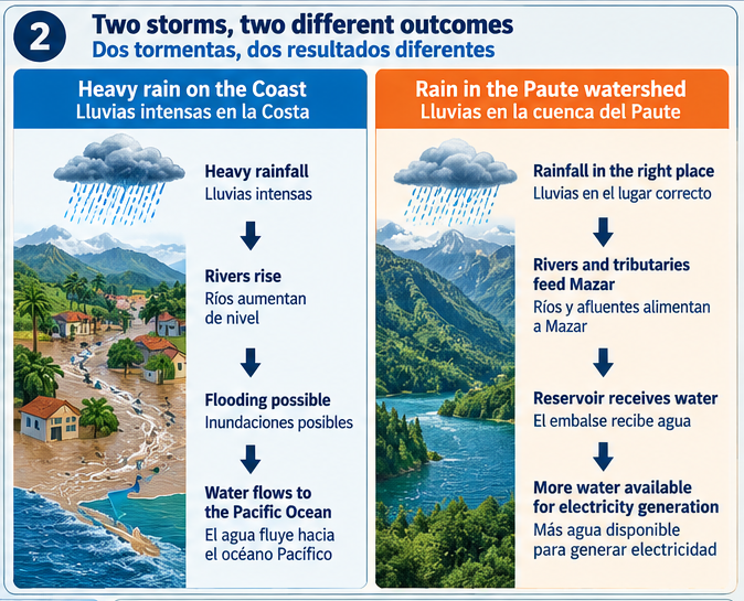
Rain falling in one part of the country cannot necessarily supply a hydroelectric system somewhere else. Mountains divide Ecuador into separate watersheds, and water follows those watersheds downhill. Heavy rain on the Coast can send enormous quantities of water toward the Pacific while the rivers feeding Mazar remain unusually low.
Ecuador isn’t one big bucket
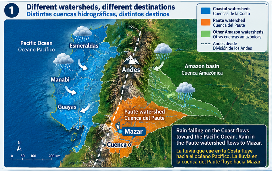
A watershed, or cuenca hidrográfica, is an area of land where rain drains into the same river system.
Mountain ridges form boundaries between watersheds. Rain falling on opposite sides of a ridge can enter entirely different rivers—and sometimes flow toward different oceans.
The Andes are a major drainage divide. Many western watersheds flow toward the Pacific. Water from the Paute watershed flows eastward into the Amazon river system. That is why floodwater in Esmeraldas, Manabí, Guayas or Los Ríos does not cross the Andes and fill Mazar.
What was happening in late September 2026?
The contrast was particularly clear on September 26–27.
According to rainfall figures reported from INAMHI, Samborondón received 106.0 millimetres in 24 hours, Montalvo received 105.8 millimetres and Jipijapa received 88.0 millimetres.
At 07:00 on September 27, Ecuador’s risk-management authorities reported six overflowing rivers: four in Esmeraldas and two in Guayas.
Meanwhile, Mazar had experienced weeks of below-normal inflow. Rain returned to parts of Azuay during the same weekend and briefly improved the amount of water entering the reservoir, but it did not immediately replace the storage lost during the preceding dry period.
Ecuador therefore had too much water in some watersheds and too little in another watershed important for electricity generation. There is no hydrological contradiction.
Mazar needs rain in the right place
Mazar depends on rivers and tributaries in the Paute watershed in southern Ecuador—not on rainfall throughout the country.
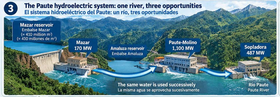
CELEC describes Mazar as part of the Paute river system. Its reservoir holds approximately 410 million cubic metres of water at total capacity.
Water arriving there supports more than the 170-megawatt Mazar generating station. It also helps regulate the Paute Integral hydroelectric complex:
Mazar → Paute-Molino → Sopladora
CELEC lists installed capacities of 170 MW at Mazar, 1,100 MW at Paute-Molino and 487 MW at Sopladora, for a combined 1,757 MW.
The system uses water successively. After water generates electricity upstream, it can continue downstream and contribute to generation again. Sopladora, for example, receives water discharged from Paute-Molino. This makes water stored at Mazar particularly valuable: it supports a connected hydroelectric cascade, not just one power plant.
A dated snapshot of Mazar
The following figures are a snapshot, not permanent conditions.
At 09:00 on September 27, 2026, the reservoir stood at 2,134.09 metres above sea level.
Its maximum operating elevation is 2,153 metres, placing it 18.91 metres below maximum at that moment.
At the same time, inflow had improved to 77.9 cubic metres per second following rain in Azuay. But the average inflow for September through that date was only 52.4 m³/s, compared with a historical September average of approximately 75 m³/s.
In other words, average September inflow had been about 70% of the historical level.
One improved hourly reading did not erase several weeks of below-average inflow. Reservoir levels depend on both the water entering and the water being released or used.
Think of Mazar like a bank account
A reservoir works much like an account with deposits and withdrawals:
- If inflow is greater than outflow, the reservoir rises.
- If inflow and outflow are equal, its level remains approximately stable.
- If inflow is lower than outflow, the reservoir falls.
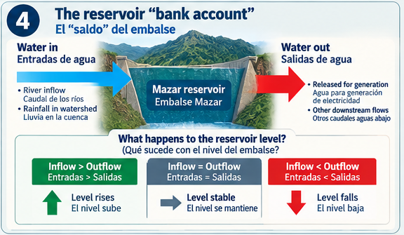
A reservoir can receive rain and still decline. If 70 units of water enter while 100 units leave, the reservoir has received water—but storage has still fallen by 30 units.
The useful question is not simply, “Is it raining?” It is: “How much water is entering the reservoir compared with how much is leaving?”
A dramatic storm is not always the most useful rain
A storm capable of flooding streets is not necessarily more valuable to a hydroelectric reservoir than several days of steady rain across the correct watershed.
Rainwater can run quickly into rivers, soak into soil, recharge groundwater, be used by vegetation, evaporate or drain into another river system. Where the rain falls, how long it lasts and how widely it is distributed all affect how much water eventually reaches a reservoir.
Why flooding can happen so quickly
One millimetre of rainfall equals one litre of water falling on every square metre. Samborondón’s reported 106 millimetres therefore represented about 106 litres per square metre in roughly 24 hours.
When rain falls faster than the soil, drains, channels and rivers can carry it away, water accumulates rapidly and flooding can begin within hours.
A reservoir operates on a much larger scale. Its stored water accumulates across an extensive watershed over longer periods. One wet afternoon—or even several rainy days—may not replace water lost during weeks of low inflow and continued generation.
The simple version
Ecuador can experience flooding while a hydroelectric reservoir needs water because the water is in different watersheds.
Heavy rain in a coastal watershed can raise rivers, flood communities and flow toward the Pacific. Rain in the Paute watershed can increase the rivers and tributaries feeding Mazar and make more water available to the Paute hydroelectric cascade.
Even when rain returns to the correct watershed, sustained rainfall may be needed to rebuild storage.
For hydroelectric power, Ecuador doesn’t just need rain. It needs enough sustained rain in the right watersheds.
Snapshot note
This explainer was fact-checked on September 28, 2026. The latest publicly available Mazar measurements used here are from 09:00 on September 27. Reservoir elevations, inflows, rainfall and river conditions change continuously.
Sources
- CELEC: Mazar capacity, maximum operating elevation and Paute Integral capacities
- CELEC: Paute-Sopladora technical information
- CELEC: installed capacity of Mazar, Molino and Sopladora
- Primicias: September 27 Mazar elevation and inflow, using CELEC data
- Primicias: coastal rainfall reported by INAMHI, September 26–27
- Primicias: rivers reported overflowing on September 27
- Ministry of Environment: Ecuador’s Pacific and Amazon hydrographic systems